Article successfully added.
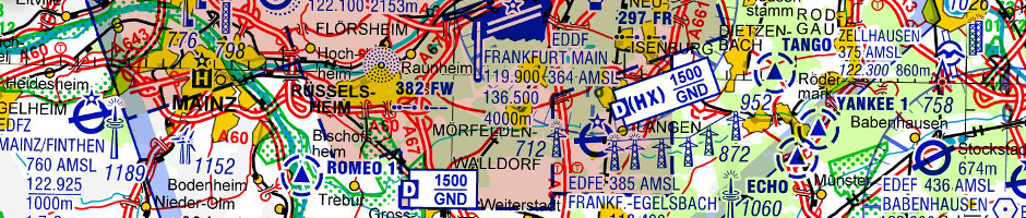
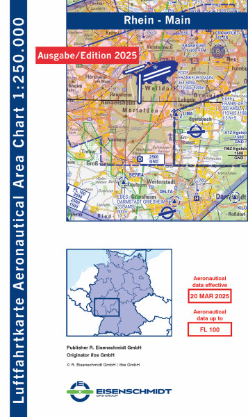
Graduated prices (ifos: V500)
You already have0articles of this price group in your cart.
Quantity | Unit price |
---|---|
To 19 | €25.00 * |
From 20 | €22.50 * |
From 50 | €20.00 * |
Prices incl. VAT plus shipping costs
This article will be released on 27 March 2025
Aeronautical Aera Chart 1:250.000 : The new map series ‘Aeronautical Aera Chart 1:250,000’... more
Aeronautical Aera Chart 1:250.000: The new map series ‘Aeronautical Aera Chart 1:250,000’ (AAC250) from Eisenschmidt GmbH is a supplement to the proven ICAO Chart Germany 1:500,000. The central idea is to optimise the representation of dense airspaces around international airports in Germany. Unintentional flights into the low C airspaces around German airports are unfortunately becoming an increasing problem for general aviation in Germany.
By centring around an airport, the sometimes arbitrary map sections of the ICAO 1:500,000 map are avoided, while the much higher resolution topography at a scale of 1:250,000 allows precise navigation based on terrestrial features such as roads and even small towns. Airfields, obstacles, reporting points and much more are equalised on the 4 times larger area compared to the ICAO map and displayed much more legibly.
The high-quality base map showing the topography is based on a map from the Federal Agency for Cartography and Geodesy (BKG); in addition to contour lines, high-resolution shading based on current elevation data allows the relief to be reliably recorded. The aeronautical representation corresponds in form and content to the ICAO map 1:500,000, supplemented by useful extensions: for example, the aerodrome circuits of the known landing sites are shown with a thin line signature. The idea is not so much to ‘fly’ the aerodrome circuit itself, but rather to avoid the aerodrome circuit when crossing an aerodrome or to fit safely into the aerodrome circuit when approaching. Model aerodromes above 500ft AGL are also shown for the first time, some of which reach as far as low airspace C and should be avoided by general aviation.
The reverse side of the AAC250 contains the familiar information from the AD section of the AIP VFR for all landing sites on the front side. Contact details such as OPS/PPR telephone numbers, e-mail addresses and websites supplement the usual information such as opening hours or fuel availability. For the first time, not only the data of all commercial airfields is published, but also the data of all UL and glider airfields with a §6 licence for microlight aircraft. A table with the SR/SS or twilight times for a central aerodrome in the centre of the page allows these times to be determined for each day of the current year.
The AAC250 series starts with the ‘Rhine-Ruhr’ sheets around Cologne/Bonn and Düsseldorf airports and the ‘Rhine-Main’ sheet around Frankfurt airport. The sheet layout has been chosen so that both sheets each represent a connecting sheet and you can navigate seamlessly from one sheet to the other. The plan is to successively expand the series to include the other commercial airports in Germany.
Ausgabe / Auflage / Jahr: | 2025 |
Flight rule: | VFR |
Area: | Rhein-Main |
Manufacturer / Publisher: | ifos GmbH, R. Eisenschmidt GmbH |
Country / Continent: | Germany |
Scale: | 1:250.000 |
Medium: | Paper / Book / Magazine |
Sport: | Engine powered flight |
HIGHLIGHT
NEW
HIGHLIGHT
NEW
HIGHLIGHT
NEW
HIGHLIGHT
NEW
NEW
NEW
HIGHLIGHT
NEW
HIGHLIGHT
NEW
HIGHLIGHT
NEW
HIGHLIGHT
NEW
HIGHLIGHT
NEW
HIGHLIGHT
NEW
HIGHLIGHT
NEW
HIGHLIGHT
NEW
HIGHLIGHT
NEW
HIGHLIGHT
NEW
HIGHLIGHT
NEW
HIGHLIGHT
NEW
NEW
NEW
HIGHLIGHT
NEW
HIGHLIGHT
NEW
HIGHLIGHT
NEW
HIGHLIGHT
NEW
HIGHLIGHT
NEW
NEW
HIGHLIGHT
HIGHLIGHT
HIGHLIGHT
HIGHLIGHT
HIGHLIGHT
HIGHLIGHT
HIGHLIGHT
HIGHLIGHT
HIGHLIGHT
HIGHLIGHT
Viewed